Open Houses in Your Region

Flood Map Open Houses are currently being held online for cities and counties across the U.S. Find an open house being held for your location, or browse resources from past events.

alert - info

Learn more about what you can expect at a Flood Map Open House.

Upcoming Flood Risk Open Houses


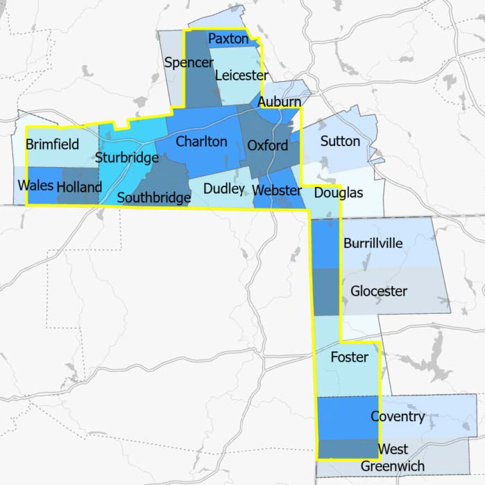
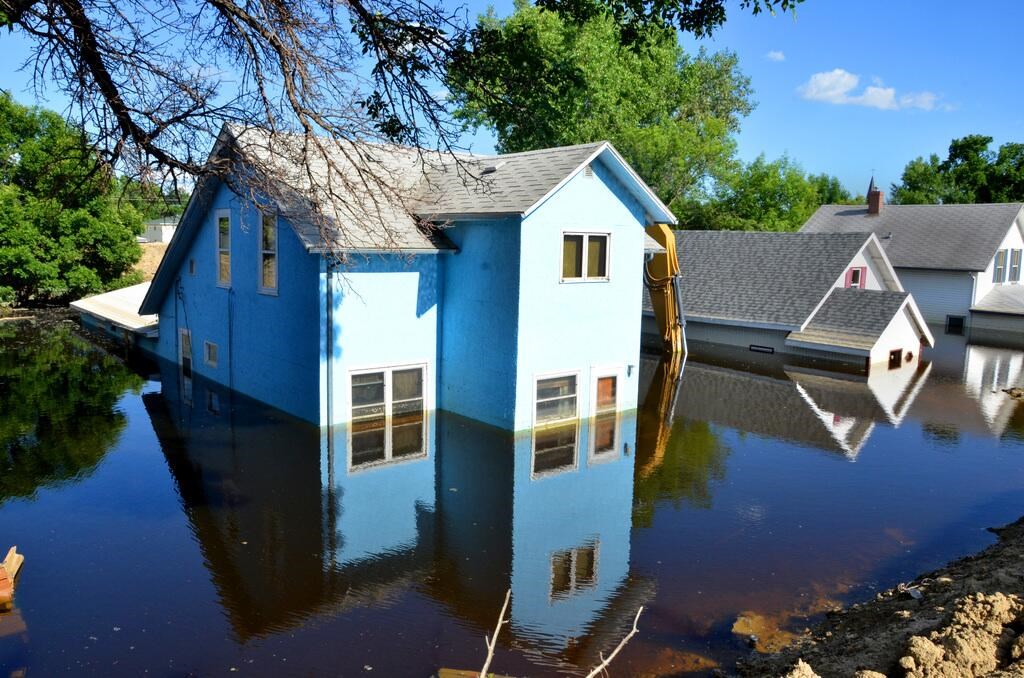
Cass County’s flood insurance rate map update is nearing completion. The new maps will provide Cass County with more accurate flood risk information that can help local officials and residents make informed decisions about reducing flood risks and purchasing flood insurance.


Davison County’s flood insurance rate map update is nearing completion. The new maps will provide Davison County with more accurate flood risk information that can help local officials and residents make informed decisions about reducing flood risks and purchasing flood insurance.


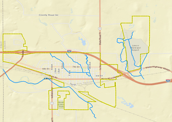
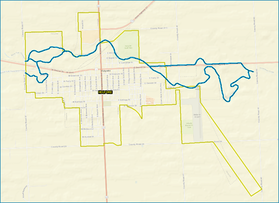
New flood maps have been developed for the City of Creede and unincorporated areas of Mineral County. If residents or businesses feel there is an error in the map, they have a 90-day period to provide scientific or engineering data. Any comments on incorrect labels or other minor errors will be received during this time as well.


image of house under water
Do You Know Your Flood Risk? Join FEMA, state, and local officials for an opportunity to view the updated flood maps for the Plymouth County Charles River Watershed Floodplain Mapping Study.

Past Events


This virtual public meeting is a chance for Denver County residents and stakeholders to ask FEMA and Mile High Flood District (MHFD) about the new flood maps and flood risk for areas near Harvard Gulch, Dry Gulch (Harvard Gulch Tributary), Sanderson Gulch and Sloan’s Lake Drainageway. They can also learn about the community’s role in the National Flood Insurance Program (NFIP).


This virtual public meeting is a chance for Arapahoe County residents and stakeholders to ask FEMA and Mile High Flood District (MHFD) about the new flood maps. They can also learn about the community’s role in the National Flood Insurance Program (NFIP).


New flood maps have been developed for Dickey County, City of Ludden, City of Oakes, City of Ellendale, City of Forbes, City of Fullerton, and the City of Monango. If residents or businesses feel there is an error in the map, they have a 90-day period to provide scientific or engineering data.


New flood maps have been developed for Stutsman County, City of Jamestown, and the City of Montpelier. If residents or businesses feel there is an error in the map, they have a 90-day period to provide scientific or engineering data.


New flood maps have been developed for LaMoure County, City of Dickey, City of Edgeley, City of LaMoure, City of Marion, Township of Grand Rapids, City of Berlin, City of Jud, City of Kulm, and the City of Verona. If residents or businesses feel there is an error in the map, they have a 90-day period to provide scientific or engineering data.


Yankton County’s flood insurance rate map update is nearing completion. The new maps will provide Yankton County with more accurate flood risk information that can help local officials and residents make informed decisions about reducing flood risks and purchasing flood insurance.


Spink County’s flood insurance rate map update is nearing completion. The new maps will provide Spink County with more accurate flood risk information that can help local officials and residents make informed decisions about reducing flood risks and purchasing flood insurance.


McCook County’s flood insurance rate map update is nearing completion. The new maps will provide McCook County with more accurate flood risk information that can help local officials and residents make informed decisions about reducing flood risks and purchasing flood insurance.


McIntosh County’s flood insurance rate map update is nearing completion. The new maps will provide McIntosh County with more accurate flood risk information that can help local officials and residents make informed decisions about reducing flood risks and purchasing flood insurance.


Brookings County’s flood insurance rate map update is nearing completion. The new maps will provide Brookings County with more accurate flood risk information that can help local officials and residents make informed decisions about reducing flood risks and purchasing flood insurance.


Beadle County’s flood insurance rate map update is nearing completion. The new maps will provide Beadle County with more accurate flood risk information that can help local officials and residents make informed decisions about reducing flood risks and purchasing flood insurance.


New flood maps have been developed for McLean County and the community of Washburn. If residents or businesses feel there is an error in the map, they have a 90-day period to provide scientific or engineering data.


New flood maps have been developed for Mercer County and the community of Stanton. If residents or businesses feel there is an error in the map, they have a 90-day period to provide scientific or engineering data.


Lake County’s flood insurance rate map update is nearing completion. The new maps will provide Lake County with more accurate flood risk information that can help local officials and residents make informed decisions about reducing flood risks and purchasing flood insurance.


New flood maps have been developed for Logan County and the City of Napoleon. If residents or businesses feel there is an error in the map, they have a 90-day period to provide scientific or engineering data.


Madison County’s flood insurance rate map update is nearing completion. The new maps will provide Madison County with more accurate flood risk information that can help local officials and residents make informed decisions about reducing flood risks and purchasing flood insurance.


Weld County’s flood insurance rate map update is nearing completion. The new maps will provide Weld County with more accurate flood risk information that can help local officials and residents make informed decisions about reducing flood risks and purchasing flood insurance.


Carbon County’s flood insurance rate map update is nearing completion. The new maps will provide Carbon County with more accurate flood risk information that can help local officials and residents make informed decisions about reducing flood risks and purchasing flood insurance. You may submit an appeal package during the 90-day appeal period. This appeal period starts July 26, 2023 and ends October 24, 2023.


A map of Lincoln County, Colorado.
New flood maps have been developed for the Town of Limon and immediately surrounding unincorporated areas of Lincoln County. If residents or businesses feel there is an error in the map, they have a 90-day period to provide scientific or engineering data. Any comments on incorrect labels or other minor errors will be received during this time as well.


New preliminary flood maps, known as Flood Insurance Rate Maps (FIRMs), were released for Dickey, LaMoure, and Stutsman counties on December 12, 2022.


New preliminary flood maps, known as Flood Insurance Rate Maps (FIRMs), were released for Dickey, LaMoure, and Stutsman counties on December 12, 2022.


A townhall meeting to allow Sanborn County residents to learn about the flooding risk in their communities


Sanborn County’s flood insurance rate map update is nearing completion. The new maps will provide Sanborn County with more accurate flood risk information that can help local officials and residents make informed decisions about reducing flood risks and purchasing flood insurance.


A townhall meeting to allow Lake County residents to learn about the flooding risk in their communities


A community meeting to allow Sanborn County residents to learn about the flooding risk in their communities


Hear from Region 1 on the flood mapping program, flood insurance rate maps and more.


New Flood Risk Maps are being finalized for Hamlin County South Dakota. Individuals have until August 15, 2023 to submit an appeal regarding any scientific errors related to determinations made on the new maps.


Broadwater County’s flood insurance rate map update is nearing completion. The new maps will provide Broadwater County with more accurate flood risk information that can help local officials and residents make informed decisions about reducing flood risks and purchasing flood insurance.


image of MA and RI counties included in maps
Residents of Massachusetts and Rhode Island are invited to join FEMA staff and state and local officials for an opportunity to view the updated flood maps for the Quinebaug Watershed Floodplain Mapping Study.


A photo of a map of a geographic area. The map includes streets and street names. A blue winding line cuts through the upper portion of the graphic.
New flood maps have been developed for the City of Holyoke and immediately surrounding unincorporated areas of Phillips County. If residents or businesses feel there is an error in the map, they have a 90-day period to provide scientific or engineering data. Any comments on incorrect labels or other minor errors will be received during this time as well.


New flood maps have been developed for Burleigh County and the communities of Bismarck, Lincoln, Wilton, and Wing. If residents or businesses feel there is an error in the map, they have until May 18, 2023 to provide scientific or engineering data.


New flood risk maps are being finalized for Arapahoe County, Colorado. Individuals have until May 17, 2023 to submit an appeal regarding any scientific errors related to determinations made on the new maps.


New Flood Risk Maps are being finalized for Grant County South Dakota. Individuals have until April 11, 2023 to submit an appeal regarding any scientific errors related to determinations made on the new maps.


New flood maps have been developed for Emmons County and the City of Linton. If residents or businesses feel there is an error in the map, they have a 90-day period to provide scientific or engineering data.


Opportunity for residents of Mt. Vernon and Davison County to learn about new flood maps and ask questions about how the maps may impact them directly.


Opportunity for residents of Bismarck and Burleigh County to learn about new flood maps and ask questions about how the maps may impact them directly.


Residents and business owners in Gonzales County, Texas are encouraged to review the latest information to learn about local flood risks and potential future flood insurance requirements.


Residents and business owners in Johnston County, Oklahoma are encouraged to review the latest information to learn about local flood risks and potential future flood insurance requirements.


Residents and business owners in Murray County, Oklahoma are encouraged to review the latest information to learn about local flood risks and potential future flood insurance requirements.


Flood maps are changing.
Residents and business owners in Guadalupe County, Texas are encouraged to review the latest information to learn about local flood risks and potential future flood insurance requirements.


The FEMA logo in black and white.
A public meeting is being held to discuss new flood insurance maps for McIntosh County.


Representatives from the Federal Emergency Management Agency (FEMA) will host an online Flood Risk Information Open House for the cities of Mankato and North Mankato, Minn., on Thursday, June 10, 2021, from 5:00 p.m. to 7:00 p.m. CT. The open house will provide residents with an opportunity to review a recently completed preliminary Flood Insurance Study (FIS) and its accompanying preliminary Flood Insurance Rate Maps (FIRMs).


Representatives from the U.S. Department of Homeland Security’s Federal Emergency Management Agency (FEMA) and Ohio Department of Natural Resources (ODNR) will host an online Flood Risk Information Open House on Wednesday, June 9, 2021, from 5:30 p.m.–7:30 p.m. ET.


graphic feature image of folded map with wavy lines representing water at the bottom

Following the September 2013 flood disaster, the state of Colorado took steps toward long-term planning and resiliency efforts


graphic feature image of folded map with wavy lines representing water at the bottom
Following the September 2013 flood disaster, the state of Colorado took steps toward long-term planning and resiliency efforts for flooding and other natural hazards.


On March 23, representatives from the Federal Emergency Management Agency (FEMA) will host a flood map information virtual open


Graphic of a folded map, with stylized water waves in front of it.
This virtual open house will provide an opportunity for residents to ask questions regarding preliminary flood maps being issued for Jefferson County, Colorado.


Graphic of a folded map, with stylized water waves in front of it.
This virtual open house will provide an opportunity for residents to ask questions regarding preliminary flood maps being issued for the City and County of Denver. The new mapping relates to flooding potential from Sanderson Gulch and Sloan’s Lake.


Representatives from the Federal Emergency Management Agency (FEMA) will host a Flood Map Information Virtual Open House for Pope County, Minnesota. The virtual open house will provide county residents with an opportunity to review a recently completed Preliminary Flood Insurance Study (FIS) and its accompanying Preliminary Flood Insurance Rate Maps (FIRMs).
Last updated